
Page 174 - UNESCO_Zatec_2021_A4
P. 174
The first military mapping (1780–1783) does not capture Ročovsko area is still one of the densest hop field
any hop fields here. This does not mean of course that landscapes in Bohemia. Hop fields here cover about
hops were not cultivated here at that time (or earlier), a third of all used agricultural land outside the forest.
but it was of limited output that the cartographers did The local villages preserve the architectural heritage of
not consider worth recording (hop fields are mentioned the hop growing tradition and their value is enhanced by
in older sources). the generally well-preserved urban structure, traditional
village buildings, numerous churches, feudal settlements
The second military mapping (1842–1852) recorded and other monuments.
a narrow strip of hop fields along the stream Hasina from
Hřivice to Solopysky and along the stream Pnětlucký to However, the Ročov area has not a hop growing centre
Pnětluky and along the Výrovka towards Černodol. Hop like the town of Žatec, which is the centre of this largest
fields are not recorded in the more easterly valleys. hop growing region with a preserved extensive complex
of architecturally unique buildings for hop processing.
The third military mapping (1876–1878) shows a similar All the attributes of the hop growing heritage that
situation in the Hasina valley, with new hop fields being
3. Justification for Inscription So the main period of the building up of the local village of Stekník.
added above Solopysky, but disappearing along the
Ročovsko could represent, albeit relatively far from Žatec,
are contained in the rural component part 01 around the
Pnětlucký stream.
ÚŠTĚCKÁ (AUSCHA) HOP GROWING REGION (2.)
hop fields occurred somewhat later. In Horní Ročov,
This second largest hop growing region in the Czech
hop cultivation had been developing since the 1860s.
Orthophoto maps from the middle of the 20 century
Republic is named after the historic town of Úštěk
th
(Auscha). It includes the districts of Litoměřice, Mělník
document the process of abolishing hop fields in valley
and Česká Lípa. According to the town annals, the
locations and the establishment of new, significantly
larger ones, on flat plateaux, where large-scale
cultivation technologies could be better deployed.
documented in writing to the year 1537. The most famous
During the second half of the 20 century, this process
hop growing location in this area is Polepská Blata, where
th
the best regional hops are produced, in terms both of
was completed, so today the Džbán hop fields are to be beginnings of the productive cultivation of hops are
found on the tops of the ridges separating individual yield and quality. In the second half of the 17 century,
th
174 valleys, but hardly at all along the main streams, where hop growing saw renewed growth, and new vineyards
wider floodplains, so typical of the river Ohře around were established on the Budín hill and on the slopes
Žatec, are missing. of the valley towards Tetčiněves. On the first military
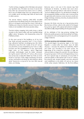
Hop field in Radovesice, Házmburk Castle in the background, Auscha Region, 2004