
Page 101 - UNESCO_Zatec_2021_A4
P. 101
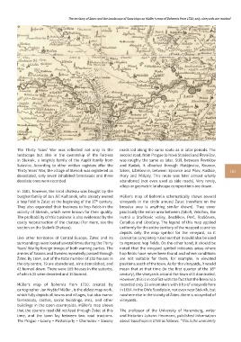
The territory of Žatec and the Landscape of Saaz Hops on Müller’s map of Bohemia from 1720; only vineyards are marked


          The Thirty Years’ War was reflected not only in the   roads led along the same route as in later periods. The
          landscape but also in the ownership of the fortress   second road, from Prague to Nové Strašecí and Řevničov,
          in Stekník, a  knightly family of the Kaplíř family from   was roughly the same as later. Still, between Řevničov
          Sulevice. According to other written registers after the   and Kadaň, it diverted through Mutějovice, Kounov,
          Thirty Years’ War, the village of Stekník was registered as   Siřem, Liběšovice, between Sýrovice and Pšov, Kaštice,   101
          devastated, only seven inhabited farmsteads and three   Mory and Pětipsy. This route was later almost wholly
          desolate ones were recorded.                      abandoned (not  even used as side  roads). Very rarely,
                                                            alleys or geometric landscape compositions are drawn.
          In 1681, however, the local chateau was bought by the
          burgher family of Jan Jiří Kulhánek, who already owned   Müller’s  map of Bohemia schematically shows several
          a hop field in Žatec at the beginning of the 17  century.   vineyards in the circle around Žatec (nowhere on the
                                                th
          They also expanded their business to hop fields in the   broader area is anything similar drawn). They cover
          vicinity of Stekník, which were known for their quality.   practically the entire area between Záhoří, Velichov, the
          The profitability of this business is also evidenced by the   Hutná  u  Staňkovic  valley,  Bezděkov,  Perč,  Radíčeves,
          costly reconstruction of the chateau (For more, see the   Čeradice and Libočany. The legend of this map applied
          section on the Stekník Chateau).                  uniformly for the entire territory of the mapped countries
                                                            depicts  only  the  map  symbol  for  the  vineyard,  so  it
          Like other  territories  of Central Europe,  Žatec and its   cannot be completely ruled out that it could also be used
          surroundings were looted several times during the Thirty   to represent hop fields. On the other hand, it should be
          Years’ War by foreign troops of both warring parties. The   noted that the vineyard symbol indicates areas where
          armies of Saxons and Swedes repeatedly passed through   hop fields have never been found and where conditions
          Žatec By 1654, out of the total number of 232 houses in   are not suitable for them, for example, in elevated
          the city centre, 79 are abandoned, nine demolished, and   positions south of the town. As for the vineyards, it would
                                                                                                           th
          42 burned down. There were 109 houses in the suburbs,   mean that at that time (in the first quarter of the 18
          of which 25 were deserted and 15 burned.          century), the vineyards around the town still dominated.
                                                            However, this is in conflict with the fact that the Berní rula
          Müller’s  map of Bohemia from 1720, created by    recorded only 33 winemakers with 8 ha of vineyards here
          cartographer Jan Kryštof Müller , is the oldest map work,   in 1654. In the Ohře floodplain, not even near Stekník, but
          which fully depicts all towns and villages, but also manor   nowhere else in the vicinity of Žatec, there is no symbol of
          farmsteads, castles, sacral buildings, inns, and other   vineyards.
          buildings in the open countryside. Müller’s  map shows
          that the country road did not lead through Žatec at this   The professor of the University of Nuremberg, writer
          time, and the town lay between two road tractions.   and historian Johann Heumann, published information
          The Prague – Louny – Postoloprty – Chomutov – Saxony   about Saaz hops in 1759 as follows: "This is the unanimity